
A view from the McCarthy Road

This journal is excerpted from the journal I kept on a trip to Wrangell-St. Elias National Park in late August and early September 1999. Parts have been excised.
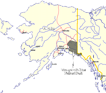
All text and images are copyright 1999 by David Manthey. All rights reserved.
The journal begins in-flight on the way to Anchorage.
Saturday, 28 August 1999
I watched out the window as the Great Land showed itself between clouds. I even tried a few photographs through the plane window of mountains, glaciers, sun on lakes, crevasses, etc.

At last we arrive. The weather is mixed clouds and warm. I get my bags, which appear intact. I lug my bags to the car rental place (inconveniently on a lower level). They charge usury rates, and I'm not supposed to take the car on dirt roads (even though the clown at the central reservation place claimed it would be okay). I lug my stuff to the car (inconveniently located on an upper level). Either I have packed better, lighter, or I am more fit, for my luggage is less troublesome (though still a nuisance) than when I headed for Denali or Katmai.
Eventually I leave the airport - not bad as both flights today were on-time. I drive somewhat randomly through Anchorage until I find a familiar road, whereupon I head north. I stop at a grocery store just past Merrill Field and procure my list of supplies.

It is slightly after 5 p.m. (local time) and Palmer is likely my last good stop for dinner. I encounter a visitors' center. They recommend the Denali Steakhouse (and the root beer). The Denali Steakhouse is on the main drag. The dining area looks like a low-class family restaurant but the prices are typical of a steak place. The dining room is divided into three areas, one of which has windows looking at the fantastic mountains which cradle Palmer. I sit in this area, which is oddly painted with a scene from the Colorado Rockies (real painting, too - not mass produced wallpaper).
I order a hamburger and a root beer from the fit young over-worked waiter. The root beer is quite good. The hamburger is very large and somewhat strange - bread and butter pickles and extremely slight amounts of mustard and mayonnaise. I set out again (though in retrospect, I wish I had just crashed for the night in Palmer).
Highway 1 to Glenallen is windy due to large mountains and sharp glacial valleys. Six or seven miles of it (the highway) are completely torn up and under serious construction. Huge earth-moving equipment trundles back and forth. Large mobile water tanks spray the road to keep the dust down. Huge articulated graders lunge up and down the embankments. It takes 45 minutes to get by the construction.
Pretty as this drive is, I am tired and wish I had stayed in Palmer. Eventually I reach Glenallen and stop at the Caribou Hotel. Glenallen has typical Alaskan architecture - everything looks a bit run down and sloppy. The Caribou Hotel is a contrast - clean wood construction. I go in to get a room. They have rooms with private baths for $120 or so, or rooms with access to a shared bathroom for $50. I choose the cheaper - this trip is expensive enough, and I have been spending too much money elsewhere.
The room is small but snug. It is located in a strange prefab metal building that seems like four trailers placed on platforms with the spaces between them turned into sensible hallways. The place caters to pipeline workers, and thus the men's bathroom is four times the size of the ladies'.
Sunday, 29 August 1999

Slow getting up. The shower was good and warm (ranking this place above those with poor water pressure, despite the communal bathroom). I organized my pack - I'm ready to go except for obtaining water. Breakfast is had at the hotel's restaurant. It is fine eggs and toast served by a friendly attractive woman.
I set out toward the ranger station, stopping for gas on the way. $1.62 a gallon - but what else would I do. Good views of Mount Drum, the more distant but larger Mount Blackburn, and the Tazlina River. I stop at the Park's visitor information center and talk with a friendly young woman. I get topographic maps of Dixie Pass. The trip is probably just a three day - this is good, since I'll be able to see all the other sights, but isn't quite as aggressive as I might have liked. I'm undecided whether to start my hike today or to play tourist in McCarthy and start it tomorrow.


I have been stopping frequently to take photographs. Along the Chitina Road are excellent vistas of the Tonsina River (with braided channel and eroded banks) and of distant mountains (Blackburn, Drum, and others). At last I reach Chitina, end of the paved road. I check in at the local ranger station hoping they will know the weather forecast. There is none - no forecast, that is. The female ranger is polite but disinclined to converse. I set out on the McCarthy Road.
The McCarthy Road is an old railroad that has been graded to form a dirt road. The railroad was built in 1908 to haul copper from Kennecott Copper Mine to Cordova (a coastal town). Kennecott stopped mining copper in 1938, and the railroad fell into disrepair. To form a dirt road, it was graded, ties with spikes and all. This leaves possible road hazards in the form of exposed railroad spikes which make driving much less carefree.
The McCarthy Road is pretty good - no huge ruts. Still, best speed ever is 20-25 mph. I have a sheet detailing locations along the road. These seem 1 mile off from the mile markers on the road. I arrive at the sub-road leading to the trailhead and take it.
This road is passable but lousy. Again mile markings (odometer readings) do not agree with the Park's opinion of distance. I find the trailhead, spend half an hour getting my stuff together, and set out. The first mile is a walk along a very sketchy dirt road. Almost immediately, a pickup truck heading out passes me. The fellow is looking to shoot himself a sheep, but was deterred by the lack of trails.

I leave the dirt road and follow a winding path, stopping shortly for a brief rest. An eagle soars by, emitting a strange harsh cry. The trail is easy and fairly level. I stop to take photographs of mountains and plants (no animals or birds as of yet). I take one more rest break before I arrive at Strelna Creek. One of the spots on the ground was covered with what looked to be feathers. Some certainly were feathers, while the bulk of it could have been fuzz from a plant (a common plant, but I still haven't taken its picture).
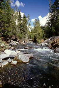
Strelna Creek is opalescent with glacial flour. Still, I fill up one canteen and iodize it. It isn't so silty as to be undrinkable - just to give the water a slight limestone flavor (and probably wear my teeth and digestion some extra amount).
The trail is narrow but clear with very few spots that are awkward for a big pack. I range between thinking how slow I am going to feeling very virile. My speed is in excess of 2 mph if the distances the Park Service cites are correct.

So far I have been on the west side of the creek. It comes to a confluence where I wish to follow the eastern branch. This necessitates crossing the western branch, which is accomplished by using stepping stones (and immersing my leg up to the ankle at one spot). My boots show admirable waterproofing while the gaiters do not.
Some distance later I cross the remaining piece of the creek. This is smaller now and thusly easier. The trail is non-existent at times and obvious at other points, but generally present and quite indistinct, meandering through willow thickets and gravel bars. On occasion it ascends the hillside, seemingly climbs too high and far from the creek, and then runs casually back to the creek with no significant drop.
After four and a half hours of hiking (I started late in the day), I decide it is time to camp. I pick a spot right after a narrow area with a cliff on the western bank. I'm on the eastern bank with my tent facing the distant mountains. The tent goes up quickly - the sky has been beautiful up to now, but it is threatening rain. I unpack what is needed, locate my kitchen, get water, etc.

Dinner is served at quarter past six. It is meat and elbow noodles boiled with bouillon. Tasty and trés filling. Much better than canned goods or freeze-dried glop. No vegetables, alas.
The temperature was 64� when I took out my thermometer. It is but an hour later and it reads 51�.
The view from my tent is probably the best I have ever had, with a mountain peak and an escarpment, alternately lit by the glorious sun and darkened by the looming clouds. I lie in my tent and write this while periodically glancing at the view.
Monday, 30 August 1999
Rain in the night. Low temperature of 36�. That, along with the rain, made it seem quite chilly. This morning is overcast, though it looked like the sun was trying for an appearance. Slow start this morning.
The girl at the visitors' center said that some people leave their tents pitched and venture up to the pass sans pack. It wasn't entirely clear where one should pitch the tent for this activity. From the topographic map and the park handout, I probably could have gone another mile before camping. I think I will leave my wet tent pitched, but will take most everything else. Better somewhat safe.
The creek runs clearer this morning - almost perfectly clear. I watch it from the kitchen as I write this.
Time is a-wasting - I must get started.
I decide to take all but yesterday's clothes, the tent, and the spare fuel. The trail fades in and out, but is generally easy to follow. Right away I take pictures of two little mossy rivulets.
It takes about an hour to reach a major confluence - according to the Park Service a good tent site is to be had here. I don't see anywhere quite as convenient as the spot I chose, though. Another hour of hiking leads me to the canyon marked on the Park Service map (not on the USGS quad). I trot down the stream bank until it terminates in a rock outcropping. I can either wade or climb around. There is a vague game path climbing upward (steep!) which I choose to follow. It seems to climb much higher than necessary, at least a few hundred feet. After a quarter mile of clinging to the steep hillside, I scramble down a less-severe looking drainage and resume walking along the river. I decide I will wade on the return.
The valley opens out to another distant confluence. Here the mountains look more rugged with barren tops and occasional patches of snow. At the confluence, the trail leads up the headland, then along the high eastern bank of the western water course. It dips back down to the stream which is now no more than a sinuous rill.
Climbing along the water, the trail becomes vague. I stalk and photograph an arctic ground squirrel. I grow weary and rest. Here I eat my lunch.


Moving as swiftly as possible, I crab up the steep hill, at first abandoning the watercourse, then regaining it. A little past two, I reach Dixie Pass. Here there be mountains. The sky threatened rain, but now the sun shines through gaps in the clouds.
To the north is a pitched descent to a braided stream, several imposing mountains and ridges, and lots of snow and stagnant ice patches. To the south I can see down the Strelna valley to distant mountains and shiny clouds. The wind is fresh and glorious.
I don't stay long, as I anticipate the labor of returning to my camp. Back down the water way. The scenery demands periodic photographs.
Eventually I am at the north side of the canyon. I remove my gaiters, boots, and socks, roll up my pant legs to knee level, and don the sandals I bought and carried for just such an occasion. After some thought, I lash my boots to my pack and put back on the gaiters.
The water is almost ice cold - the result of glacial runoff - but is not too severe. I cross the stream and find a curious white substance. There is a sulphurous smell and a minor trickle of water has strange white strands waving in the current. It looks a little like poached egg whites. In a still pool, it looks more like a white powder. Strange.

The rain decides to be continuous, light, and with medium droplets. I plunge into the water. The canyon is perhaps 30 yards long; longer than I suspected. At times I can walk on a low ledge; at others, I must wade. I come to one spot with a chest-deep pool. This I manage to avoid, never going more than gaiter-deep. The entire process is cold and exhilarating. Although I had intended to take photographs in the canyon, I did not.
I emerge at the far end, clamber onto the bank, and begin reversing the footwear process. The rain is more pronounced, but still not bad.
I continue, sometimes on the same side of the creek as before, sometimes on the other side. Continuing on the west side, the path becomes very wet. I emerge in the pretty mossy rivulets I was so delighted with this morning. Just ten minutes later I am at my tent.
I change and begin to prepare dinner. It begins to rain. As soon as my food is cooked, I go and sit in my tent to eat.

When I finish eating, I climb out of my tent to deal with the dirty dishes. I thought I had a good view from my campsite before - I was mistaken. A stunning rainbow - four distinct bands - arcs perfectly over the mountains. A secondary bow is even visible. Still raining. I grab my camera and burn half a roll of film. [As an aside, the stars visible at Lane Cove, Isle Royale, were every bit as impressive, but in a completely different manner.]
The rain stops, the sun gleams, and the rainbow fades. Ever so lovely.
Tuesday, 31 August 1999
Warmer last night than the previous one. Low only about 40�. Yesterday's high probably didn't clear 60�. Rain, and lots of it, during the night. Am somewhat sore this morning, and loathe to pack up with everything wet. Still, it looks like the sun may be coming out. There is a dusting of snow on yonder mountains.
It is wet, and I have stowed my camera. I have shot half the film I brought and may run out before my trip is through. Hiking out is much faster than hiking in. Partly this is the lack of photography. Partly it is the grade (downhill on the way out). Partly it is familiarity with the location. And, lastly, I feel fine.
I see all manner of interesting fungi, mosses, and lichen. I cruise by them all. I stop for lunch at the place where the trail leaves Strelna Creek. I refill my water and set out, striding rapidly through the alder and willow. A little more than an hour gets me back to the road, which has its attractive spots, but I hurry on. The road is longer than I remember, which is odd since the rest of the trail was shorter.
The car is where I left it, only it has been joined by a brute-force pickup truck and a small compact car. I change clothing - mine is soaked from brushing against bushes, from walking through a stream, and the rain.
The drive back to the McCarthy Road is uneventful but seemingly long. I'm technically not supposed to have this car off the paved road, so in some measure I am being extra careful with it. The McCarthy Road is wide and reasonably well maintained, dire warnings about railway spikes not withstanding. In some spots I slow to 15 mph. After about mile 30 (the road is 60 miles long) it improves and I rarely travel less than 25 mph.
Two bridges of note along the road. One in service at mile 19 or so is a large metal trestle with a single-lane-wide top. The surface is wooden boards laid diagonal. A young couple traverses a lower catwalk. It looks like the catwalk is supposed to be off limits. The young man says that 10 years ago that wasn't the case. An older man says that 2 years ago the catwalk didn't have handrails. I may try the catwalk on the way back.

The second bridge of note is an old wooden trestle partially collapsed. It is made of great logs but has been the victim of rot and neglect. The auto road drops down and crosses on a modern small concrete bridge. Later I found out that the trestle was built twice (having once been lost to a fire). The first time it was a mere 4 days - the railroad must go through.
The remainder of the McCarthy Road is fairly tedious with a few stunning views of mountains. The National Park Service maintains an information kiosk near the end of the road (along with an unmaintained campground and some public toilets). I stop and talk with the attractive young woman. She recommends two potential day hikes. We chat amiably about subjects as diverse as knitting and insects, then I proceed to "Glacier View Campground", which does, indeed, have a view of the Kennicott Glacier (also a shower).
I get a site that is too near the road but has a good view, pitch my tent, pay for two nights and a shower, and get some water. The footbridge to McCarthy is half a mile away.
Grabbing my camera and rain jacket, I walk to McCarthy. There are two restaurants before the footbridge (and a café at the campground). The footbridge is long and narrow, but not very interesting. The water below, however, is a cauldron of glacial silt. Mount Blackburn and Kennicott Glacier lie beyond. On the opposite side of the foot bridge is a motor pool, which completely ruins the concept of no vehicular traffic.

Another half mile (and then some) places me at the McCarthy historical museum. This is an age-worn rail depot building and an old boxcar. I go into the boxcar first as it is invitingly open. The exhibits inside are sparse and somewhat crude. It does tell me that July 17th would have been a good day to visit to watch a glacial lake become undammed and make the river volume increase by 20,000 cubic feet per second. I exit the boxcar in time to meet Jesse, the caretaker of the museum. Inside is similar to the boxcar - many fading exhibits presented in an unpolished manner, which more space than is used. Only a few specimens stand out - two old sewing machines, one a White and one a Singer, an old mining helmet with acetylene lamp, a miscellany of picks and tools. An extensive photo montage is interesting but will probably be more so after visiting the old mining town of Kennecott (glacier and mountain spelled with i; town and mining company spelled with e) .
The rest of McCarthy is small shops and hotels catering to the tourist trade and private residences, all in Alaska-style architecture.
I return to my campsite, eat dinner, and take a shower. The shower is a strange affair, with an electric pump and gas on-demand hot water. It is sufficient but not fantastic. I return to my campsite where I sit at the picnic table, drink tea, eat fig newtons (much abused in my travels), and write in my journal. Tonight promises to be chilly. There appears to be only one other campsite in use (out of 20+ sites). They are a pleasant German couple.
The sun has been setting around 8 p.m., but so far it has not been dark enough to warrant a flashlight. All of the local buildings have their own private generators which produce a steady background thrum.
Wednesday, 1 September 1999
Played tourist today. My right ankle is feeling a bit tender (having twisted it yesterday - though it felt fine then) so I decided today would be my duff day. I probably ended up walking 15 miles, but no "hiking".
Up late (8 a.m. or so). Despite a cold start to the night, it never dropped below freezing. Rain all day today, ranging from very light to moderately heavy. Talked with the woman who runs the campground a bit, then grabbed my fleece and rain jacket (with gloves and hat in pockets) along with my camera bag with granola bars, et al., in the outside pouch. Walked to McCarthy.
There are vans going the five miles to Kennecott every hour. Odd hours are run by Wrangell Air, even hours by McCarthy Air. All of the vans (both companies) are shiny white. I arrive at 9:30, so the next available van is at 10. However, McCarthy Air's driver hadn't shown, so no van service. I ended up walking up to Kennecott on the carriage road. The main road is the old railroad bed and is used by vehicular traffic. The carriage road is used by foot traffic (such as myself), and reminded me of the walks Dad would take us on - easy, pleasant, interesting.
Kennecott is a run-down out-of-service mining town. Some of the buildings are in use and in good repair. Others have collapsed completely. Most are somewhere in the middle, open to the elements and degrading but built reasonably well to begin with. I take a few photographs as I walk around. Not very many as it is raining and dim. Some buildings are open to wander through. Most are not. The Park Service bought about half of them last year and is working on some of them. No doubt they will make everything safe and uninteresting in the end.
The copper ore was mined from five separate sites, all a few thousand feet above Kennecott. From there, the ore was sent via aerial tram to a mill, which is the largest building in Kennecott. The ore was crushed, sifted, gravity and flotation separated, and either bagged or sent to an ammonia-leaching plant for further processing. It was then sent via rail to Cordova. All of the buildings are the expected support buildings - power plant, machine shop, hospital, bunkhouses, private homes, school, dairy barn, assayer's office, etc.

At 1:30 I went on a tour (guided) led by Jesse, the museum caretaker. I'm the only one on the tour. Much is a repeat of what I saw on my own, but we did go into the power plant and mill building, which were fascinating. Jesse knew a lot of coarse history and personal history of the mine, but lacked fine detail of the copper processing technique - which is not to say I didn't learn things.
The tour lasted until 4:30 because I was an interested audience and Jesse enjoyed giving the tour. Afterwards, I walked back to McCarthy, again via the old carriage road. I arrived at McCarthy before 6 and went to Tailor-Made Pizza for dinner. It was filling and decent and not too expensive considering that everything must be transported a great distance.
Tomorrow I plan on hiking to the glacier (to justify carrying my crampons). It would also be interesting to hike to the old Bonanza mine, but I'm not sure my interest will hold that long.
Thursday, 2 September 1999

A tiring day. Up around 7:30; ready to go at 8:15. I seem to have decided to cross the Root Glacier (part of the Kennicott Glacier) and to go to Donoho Lakes. I walked to McCarthy, eating the last of my fig newtons en route. I have my full pack sans tent and BRFC (only 2 or 3 days worth of food), plus I have my crampons. Took the shuttle to Kennecott.
The drive up to Kennecott was interesting. Very rough due to the wrong suspension in the van. Three quarters of the way to Kennecott, we slowed down since we were passing a farm. A van ahead of us was stopped. The CB chatter was amusing:
"Someone tell Jeannie that her pigs have gotten loose again." Sure enough, a half dozen pigs are wandering around. This message from the van ahead of us.
"Just herd them back into their pen." Clearly from Jeannie who is elsewhere at the moment.
"I worked for two years in Iowa on a pig farm and I had enough of that." The dogs, each chained to its dog house are worrying a pig.
Our driver gets out. The other driver gets out. The pigs are herded. We continue. Our driver comments that driving a van all summer is a lot more varied than he imagined.
Once I arrived at Kennecott, I immediately set out. Rain ranging from light (just enough to need a hood to keep it off my glasses) to heavy. The first mile of trail is an easy grade that used to be a road. The trail is fairly level except for a bit that traverses Jumbo Creek. The trail then becomes loose singletrack and drops to the glacier. This arrives at the glacier at the point that the moraine ends and the white ice (ice clear of débris) begins.
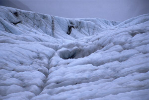
I don my crampons (which stay on my boots just fine if they are secured just so). I dither a bit as I've never done anything on a glacier before and don't want to do anything too stupid. I watch a group of five people start (one guide and four sports), then pass them and head to where I think I should be going. The terrain is hummocky with crevasses and shallow depressions appearing without warning. Mounds crest up 40 feet or so. Rain and melt water occasionally plunge down through fissures and sinkholes. Everything is wet with rain.
There are numerous small depressions, ranging from half dollar size on up. These are typically filled with a bit of fine gravel and some exceptionally clear water. There are also water pockets - some a few inches, others deeper than my hiking poles, each filled with azure water.

Very wet. I hike to a central moraine, remove my crampons, cross the moraine, re-don my crampons, and continue on the ice. Here the terrain becomes more difficult. After an hour and three quarters on the ice in the sometimes driving rain, I decide I have had enough and head back. Going back is no easier - what I have gained in experience I have lost in tired feet.
Just after recrossing the central moraine, I encounter the group of five people on the package tour - we comment from a distance that it is a humid day. Partway back along the remaining ice, the rain relaxes enough that I take out my camera.
I see a small waterfall rushing headlong into a complex crevasse. I see a pretty little pool. The ice is full of interesting striations formed by rock powder. The cloud deck lifts slightly.
As I arrive back at the start I met a fellow without crampons (but with an umbrella). His name is Jason, and he just finished at Kenai Fjords National Park as a seasonal ranger. We talk about parks - he's delighted to see someone not on a tour but just doing their own thing. He heads off towards Erie Mine, while I angle toward Kennecott.
The rain is almost nonexistent for a spell. I elect to walk back to McCarthy (saving $5). An hour and a half later I am very foot sore and in town. I buy an ice cream (even though I've been in the rain all day, I am not cold), encounter a fellow who hiked to the Bonanza Mine, and head back to my campsite.
At camp it is raining. I boil some pasta, fuss with gear, etc. I am undecided about tomorrow. I am tired and do not feel like hiking in the rain again, so, if the weather is bad, I will probably head back to Chitina. On the other hand, Bonanza Mine sounds interesting.
Friday, 3 September 1999
Woke early having slept soundly. Rain during the night, but a cloudy grey dawn. Up and packed by 8:30. Left the campground after talking with the woman proprietor and greeting all the cats.
I decided not to do a hike today - I don't want to drive out at night and I just don't feel energetic. Drove back down the McCarthy Road. It was easier going without the dust. I stopped at a few locations to take photographs, notably the top of the old railroad trestle and the bottom of the steel span. Arrived at the end of the McCarthy Road without excitement around 11. Drove north to Glenallen, stopping often just because I couldn't remain cooped up in the car.
Along the way I stopped at Liberty Falls, which is halfway between the Richardson Highway (Route 4) and Chitina. The falls are impressive but very hard to view due to an inconveniently located boulder. I clambered up a poor trail to the top of the falls where the view was congruently obstructed.
The clouds are gradually lifting, and it hasn't rained in a while. There are hints of great mountains across the valleys. The valleys are full of neatly contrasted pines and alders; the pines are dark and the alders pale. It may be a fall thing; I don't know.
At Glenallen I bought more gas and a snack, found a campground, and pitched my tent. Went to the Caribou Restaurant for dinner (associated with the motel I stayed in a few nights previous).
"No more than his fair share of gristle." The steak is not especially good, but I have a pleasant apple fritter for dessert. This is basically fried dough with cinnamon and apples and a sugar glaze on top. Compared to the McCarthy area (or breakfast prices), the meal is a cheap $14.
Saturday, 4 September 1999
A good beginning and a desultory end to today. Awoke, etc., and struck my tent by 7 a.m. Went to "The Hitching Post" for breakfast, which was good and cheap - excellent bacon, plus I got to listen to an old-timer tell some new guys some details of an upcoming lumbering/land-clearing job. Set out toward the Nabesna Road.
The sky is full of fantastic clouds, shifting constantly. The initially obscure the upper ramparts of the mountains, but Mount Sanford clears enough for a photograph. When the sky is interesting, I can drive forever.
Arrived at the ranger station in Slana a little before nine. Since most trails are open to ATVs and it is hunting season, the pleasant ranger recommends the hiking-only trail to the Skookum Volcano Formation. This is 39+ miles down the 46-mile Nabesna Road. I fill my water bottle then set out.
In general, the Nabesna Road is in excellent condition. It is a dirt/gravel road with occasional turnouts. Some of these have picnic tables, pit toilets, and areas officially designated as campsites. According to the Park Service brochure, there are three fords on the road across different streams. This is the only part of the drive which could prove troublesome, but the ranger said it wouldn't be a problem.
I stop at Dead Dog Picnic Area - there must be a story to a name like that - then proceed. It is a much faster road than McCarthy, and I reach and cross the first ford. The second ford is only a mile and a half further. In it I can feel the car rebel and get sucked down, but not enough to do more than cause a bit of worry.

The Skookum Volcano trailhead is well marked. I rig my pack to nearly day-pack light and set out. The first mile and a half winds through some alder. The ground is strewn with volcanic rock ranging from very porous to more Swiss-cheese like.
The trail joins the stream (the alders border the stream, and I have been just out of sight of the stream the entire way). The stream bed is ludicrously marked with cairns - as if one can't find the streambed. The stream curves to the east, running between two steep hills. After another few miles, the stream peters out but the streambed keeps going. Rather than follow the streambed, I walk up the brush and rock covered hillside. Very steep; probably close to 100% grade on average. It is thick with willow in some spots; others is loose rocks which tumble and slide at the least provocation.

I gain the top of a scrub willow covered bench area, top of the ridge but not the highest point. The highest point lies beyond a precarious rock pile, which I elect not to attempt.
After looking around, I descend a steeper way. Across the southern valley (the drainage I came up) I can see some neat rock formations. I angle downwards, tango with some alder, and am splashing in the stream once more. I cut over to the next drainage and follow it until it enters a shale-like rock formations. I take some photographs, but don't proceed too far into the rock canyon, as I would like to get to Palmer before dark (see later comments).
Skirting some jumbled rocks, I edge over to the more westerly drainage. This has a spine of sandstone forming hoodoos and slickrock-type mounds. I spend some time trying to take a picture of myself (probably unsuccessful).

I return down the drainage. Just after I pass the confluence between the rock canyon and the slickrock drainages, my steps dislodge the rocks I am standing on, and I take a fall. I'm okay aside from my hands. A light nick on my right hand, but I have flensed a few square centimeters from the heal of the palm of my left hand (plus minor surrounding abrasions).
Bright red blood prompts me to stop, clean the wound, and bandage it. I don my lightweight gloves to keep the dressing in place and absorb the oozing blood.

The rest of the trip down was uneventful. My hand stings but doesn't hurt. The clouds continue to move merrily, one minute cloudy, the next brilliant sunshine. I get back to the car and put my gear away, talk to a couple setting out on the trail, and get going.
The fords aren't as bad in reverse since I know them a little better (take the upstream side of the second ford from Slana). I stop for a few photographs but never long. Pavement, and then the highway.
Clouds form into rainstorms, very localized with banners of tattered mist draping to the ground. At some point it is shiny-sunny with a gentle rain. I'm not hungry, despite having not eaten much today, so I don't stop until Glenallen. Outside of Glenallen is a small airport with amazing clouds above it. Prior to that were a few vantages with similar clouds. These have a sort of bright spot in them I don't know what causes it.
Saw a moose cow wanting to cross the highway. A busload of tourists were ogling it. She gangled off into the woods before I arrived. On the hike I saw I tremendous number of rabbits.
Stopped in Glenallen for petrol (this car guzzles the stuff), then proceeded toward Palmer. The big state fair is in Palmer and I figured I would spend tomorrow there.
...
Some reflections and observations on Wrangell-St. Elias National Park:
The rocks varied immensely from place to place. In Dixie Pass, they were generally fist-sized or smaller and highly striated and crossed, with plenty of large boulders of similar demeanor. At higher elevations the rocks were more homogenous. In McCarthy-Kennecott, the rocks were often two-toned, dark basalt and light limestone. Along the Nebesna Road the rocks were granite-like in appearance, much like the higher elevations of Dixie Pass. There were also slate-like and slickrock (the most surprising), and volcanic rock [vitriolic basalt].

The terrain is steep. Strelna Creek ran down a U-shaped glacial valley with a water-carved V gorge. Dixie Pass was a genuine col, two very definite cirques. McCarthy lies along a shallow U valley whilst Kennecott perches on the upswing of the U with the base still filled by Kennicott Glacier. Skookum Volcano defies easy description. Water and wind formed its land.
Vegetation was the lushest I have seen in Alaska. Thick willow and alder. Some birch. Much spruce. Sedges and grasses are common with low marshes and lichen-covered hillsides. Lots of different mosses and flowers.
A view from the McCarthy Road
All text and images are copyright 1999 by David Manthey.
Back to Manthey Outdoors.