
The Degree Confluence Project's goal is to visit each integer crossing of latitude and longitude. The visitors to each of these confluences take photographs and write about their journey and the location. By its very nature, this is a worldwide project, involving thousands of people in virtually every country on the globe.
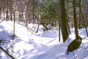
This is a delightful way to combine several of my hobbies. Frequently, the trip to the confluence involves hiking or canoeing (though some are near roads). Once at the confluence, one takes photographs to best show off the area. This can range from simple documentary pictures to scenic vistas. Getting there is most of the excitement, and requires a GPS or clever use of maps.
I have visited or attempted to visit the following confluences:
As part of visiting confluences, I have also made up several maps. See, for example, my trip to 41°N 73°W.
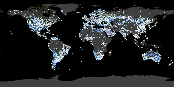
At the suggestion of my brother Ben (a fellow confluence hunter), I wrote a program to generate a Worldwide Composite Map based on the index photographs of all of the confluences that have been visited or attempted. I now maintain a variety of maps all based on this theme, including maps of each continent and VRML versions of the worldwide maps. These are automatically updated daily.
I have helped prepare certain data about the confluences. Some of these data are visible in the composite maps, while other items are available via a CSV file. Each data item is listed below along with its source and what I know about its accuracy.
The composite map shows the outline of the various continents and water bodies within the continents. These data are taken from the USGS Global Land Use data, specifically the Global Ecosystems dataset. Any area marked type 14 (inland water) or 15 (sea water) is regarded as water. All other areas are regarded as land.
The land use information has a resolution of 30 arcseconds. The USGS has details about how the data were generated and their expected accuracy. Although the USGS site offers the dataset as a geographic projection, their notes indicate that it was originally computed using a 1-km resolution Interrupted Goode Homolosine Projection. Furthermore, the conversion to a geographic projection lists a spherical radius, implying that the reprojection was not done on a standard ellipsoid. For use with the composite map, the data have been treated as if they were in the WGS84 datum, which will introduce some error.
One of the data items for each confluence is the distance between the confluence and the nearest shore. This was calculated using the arc-surface distance between the confluence and the centroid of each 1 arcsecond x 1 arcsecond region taken from the Global Ecosystems dataset discussed above.
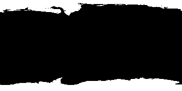
Each confluence that is not on land was checked to see if it was located on a near-permanent icecap. The icecap data was derived from the spectral reflectance data collected from The Living Earth data set, as processed by John Walker's Earth Viewer. If the color of the Earth satellite imagery was close to white and over a specific brightness threshold, it was considered to be part of the ice cap. The brightness threshold was determined experimentally and has not been verified in any manner. The actual data used is shown to the right.
Any confluence that is on land or ice cap and was not eliminated based on the pole reduction algorithm (see the Degree Confluence Project website) is marked as a primary confluence.
The altitude of each land confluence (and each inland water confluence) was taken from the USGS GTOPO30 dataset. This lists the altitude of each 30 arcsecond x 30 arcsecond region on Earth in meters.
The altitude data are derived from a wide variety of sources of varying accuracy. The different sources are detailed by the USGS. There is a gap in the data along the prime meridian near the south pole. For this area, a linear interpolation was done of surrounding altitude data.
Return to Manthey Central, Orbital Central, or the Site Map.